The damage in Kyrgyzstan: well delineated. Satellite maps speak
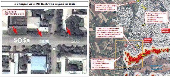
(BRUSSELS2) The "pogrom" type riots that affected southern Kyrgyzstan in mid-June were carefully observed by satellites. The United Nations satellite program (UNOSAT) has published several maps showing the extent of the damage. According to his analysis, 1877 buildings were damaged in Osh (1805 totally and 72 severely). And 433 buildings were affected in Bazar-Kurgan (401 totally and 32 seriously). Satellite photos have identified 73 SOS signs and 32 roadblocks in Osh, indicating Uzbek neighborhoods hit by the ethnic crisis. In Bazar-Kurgan, no SOS distress signs and only three road obstacles were detected. No damage was identified in the town of Nooken, on the west bank of the Kara Unkur River.
Organized and sectorized destruction
According to the first analysis by UN satellite experts, there is thus an east-west axis of destruction in Osh passing through the center of the city. "There is a series of destructions over 7 major areas, with well-defined boundaries between affected and unaffected areas. Half (52%) of the affected buildings identified are located in one of the six zones". In Bazar-Kurgan, the damage is concentrated in the center and northeast of the city, mainly in four areas. Nearly three-quarters (72%) of the identified affected buildings are in two areas.
In both cases, the preferred mode of destruction was "arson" detectable "due to the prevalence of destroyed roofs coupled with visibly intact load-bearing walls". What "suggests that the majority of building destruction likely occurred as a result of the afternoon fires detected on June 12 and 13, 2010". Additional clarification:A large majority of the buildings affected were directly accessible from the roads, suggesting that the suspected arson attacks were perpetrated by individuals or groups who restricted their movements to major transportation routes."
In most cases, the buildings affected were used for habitation or were located in residential neighborhoods." There are a few instances of destruction or damage to industrial warehouses or commercial and public facilities. No damage was observed to the transportation network (roads, bridges) or other key infrastructure sites in the city".
(Nicolas Gros-Verheyde)
Download :

Comments closed.